Tuesday, November 20, 2012

Sacramento National Wildlife Refuge and Llano Seco Rancho in November


Late October, early November is the time to go birding at the Sacramento National Wildlife Refuge and surrounding areas in Colusa and Butte Counties in northern California. I heard one individual listed a thousand or more species visiting the refuge this time of year. My list isn’t so impressive, and I’m not the Big Year type birder, but in just a few hours involving a small hike and the auto tour with a few stops, I racked up about 30. But more astounding than that is the production put on by the migrating birds, on land, water, and in the sky. Thousands of snow geese, Ross’ geese, and white-fronted geese blanketed islands of land completely with solid shades of white and brown; while waterfowl and shorebirds dotted the waters in amazing numbers. Then the geese would fly overhead, cackling a billion conversations in intricate formation while taking off, or coming in, or passing through. A little drama involving a small blackbird chasing off a red-tailed hawk three times its size topped the show.

More than 40% of the millions of waterfowl that winter in the Sacramento Valley find habitat in this refuge. I couldn’t help but wonder if this spectacular view I was taking in wasn’t a bit of overcrowding due to diminishing wetlands elsewhere in the valley. Agriculture has taken up much of the valley wetlands used by migrating birds. The good news is groups such as the Audubon Society are developing programs with rice farmers to increase wetland habitat for these thousands of species. Speculation aside, I drove out of the valley with a list including a variety of taxa--killdeer, northern flicker, gadwalls, northern pintails, great white egrets, herons, golden-crowned sparrows, marsh wren, coots, blackbirds, northern harrier, shovelers, mallards, willets, and meadowlarks; not to mention the adorably colorful black-neck stilts, ruddy ducks, goldeneyes, scaups, and wigeons. A few quail and a raccoon crossed the road on our way out. In December a couple of years earlier, a similar list included two peregrine falcons.

The refuge is off of Interstate 5 between Sacramento and Redding, just about 7 miles south of the town of Willows. But to the east, heading up State Route 45 towards Chico, the birding continues. Driving along the 18,000 acres of Llano Seco Rancho, an historic ranch turned into conservation lands and an organic hog farm, I was able to add to my list burrowing owl, ferruginous hawk, and long-billed curlew to name a few. My photos don’t do the scenes justice, so the next time you’re flying up or down Interstate 5 in this area in the winter, it would be worth it to take the time to stop at the refuge and pull out the binoculars.


Snow and Ross' geese

Yes, those are all birds

Wednesday, October 3, 2012

Heritage Trail Museum Tour


Generally, when junk mail comes in, it becomes kitty litter. But a little card came in that caught our attention. On the weekend of August 11-12, all museums participating in the “Heritage Trail”, from Roseville, California to South Lake Tahoe, were free. Now we usually catch a museum or two when we travel far from home, but who ever goes to museums near home? It’s not something I would ordinarily do on a Sunday, but we figured why not.

First stop was the Maidu Indian Museum in Roseville. We had passed it a thousand times and never even knew it was there. Inside the museum are a number of millennium-plus old artifacts and artistic, interactive displays and films of the lifestyle and culture of the Nisenan Maidu tribe, who for thousands of years, lived in the oak savanna along the American River before they were pushed out by the gold rush settlers in the 1800s. The land became farms, and then the farms became today’s jungle of asphalt and concrete. A few Nisenan Maidu remain to preserve, share, and teach their ancient culture. Behind the museum, we took a walking tour through a 30-acre parcel of open space, which holds what remains of a Maidu village, with petroglyphs, grinding stones, and carved-out rocks that even our interpreter didn’t know what they were used for. 
Surrounded by houses, streets, schools, and a large community park, a walk through the ancient Maidu village was like a walk into the past. Understanding Maidu culture is to understand nature--to respect, love, and give thanks to the grasses and the trees, the acorns and the waters that gave this area life.  

Our next stop was in the small foothill town of Colfax, lunch at the Colfax Max diner, where the menu offered elk, kangaroo, and alligator burgers (but I stuck with the beef). Then the Colfax Heritage Museum, situated by the old railway depot, next to a decommissioned train car that is now a music shop. The small building was filled wall-to-wall, ceiling-to-floor with history. Every antique household product, gadget, tool, or you-name-it was there, from the temporary campers building the railway in the 1800s to the agricultural tycoons of the early 1900s. It’s not a place I could walk into and see everything in one half hour. But I could imagine myself as an old railroad worker, shopping for a bottle of this or a cask of that or an ancient pharmaceutical sitting on the shelf. But there was so much more to see in one afternoon, so we grabbed our free cookies and started back down the hill.

Free root beer floats and dramatic historical enactments were the lures that brought us to the museum in the historical courthouse in Auburn. Auburn is the seat of Placer County, and the first floor of the grand capitol-style 1889 courthouse had displays of native Maidu and other historical artifacts, the Sherriff’s office of the early 20th century, and a large chunk of pure Placer gold. Annie, the husband murderer, was locked up in the women’s jail below the courthouse, or at least the volunteer who acted as her was kind enough to sweat all day in 1880s clothing in a dungeon of Auburn heat for our edutainment pleasure. Two more Auburn museums filled up the rest of our afternoon—the Auburn Joss House Chinese museum downtown and the Bernhard Family museum complex, an estate next to the Placer County fairgrounds. The latter consisted of a restored 19th century ranch house, winery, and garage with 19th century farm wagons. A horse-drawn wagon of the time sat in the driveway, and we were invited to climb aboard and have our photo taken. While we took our tour through the well-preserved lifestyle of the past, a volunteer churned out homemade ice cream, while another volunteer provided fresh-baked buttermilk biscuits. Lack of refrigeration in those days meant ice was hauled off of the mountain and brought down in a covered wagon, used for ice cream, and placed in an “ice box” to keep the freshly slaughtered meat cold. The wood-burning stove kept the kitchen so hot, the residents had to do a lot of their cleaning and cooking duties outside, such as baths in a bucket and laundry on a washboard. We brought some of the historical simple-life home with us—buttermilk biscuit batter in a small cloth bag tied smartly with a bow, which provided a delicious snack while working in our overly complex, modernized world. 

Saturday, September 29, 2012

Wonders of Bohol


July 5, 2012. After our adventures on Panglao and Balacasag Islands, including getting lost trying to walk from the beach to the hotel, our day had just begun. We hired a guide for the day to take us to the great tourist spots around the island of Bohol.

Loboc River.  Traveling east from Tagbiliran City, the Loboc River was our first stop. The Loboc River is in the southern part of Bohol Island, just north of the town of Loay. Loboc is a quaint tourist town, and our driver pointed out the centuries-old buildings and churches along the way. The Loboc river cruise on the floating restaurant was highly recommended, so we took the advice.  Our second lunch was a buffet of grandeur delicacies and live entertainment, while we floated on the wide green river between Loboc and Busay Falls to the north. Suddenly, a dock came into view, and on the dock sat a long line of pink-costumed men and ladies singing and playing ukuleles. As the boat sidled up against the dock, we were serenaded with traditional songs, and some of us disembarked to join the minstrels. I haven’t played much ukulele, if ever, but when one was handed to me, I watched, I imitated, and I jammed on a tune or two. Then our floating restaurant/dance party brought us back to our waiting driver in Loboc. We were ready for our next attraction.

Tarsier Sanctuary. I am not big on zoos, but I am big on recovery of threatened and endangered species, even if that means keeping them in captivity for safety and propagation. The Philippine tarsier is the smallest primate in the world. It looks like a monkey and is roughly the size of a tiny bat. Its body is small enough to fit snug in the palm of someone’s hand, while its large brown eyes are the dominating feature of its little face. It exists only in a few of the Philippine Islands and is in danger of extinction. The Philippine Tarsier Sanctuary, near the town of Corella on the west side of Bohol Island, is run by the Philippine Tarsier Foundation, a non-profit organization established for the conservation of the tarsier and its habitat. We visited the netted enclosure and took a small self-guided tour, with park personnel available to point out the 10 resident tarsiers resting in the trees. They are so small, they would have otherwise been impossible to spot. A nocturnal species, most of them were asleep, but we could see them well enough. Since we were trying to cover all of Bohol and its ancillary islands in one day, we did not take the time to hike the more wild side of the sanctuary. It’s on my bucket list.  

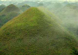
Chocolate Hills. The Chocolate Hills National Monument is something that is not to be missed. We were driving north through the center of the island on the Loay interior road towards the town of Carmen, passing through typical island scenery filled with green foliage, small towns with open-walled stores, motorcycles zipping around, and old men walking oxen along the road or leading them through the soggy fields as they tilled the soil by dragging heavy wooden plows. Then suddenly, as if we were in a Dr. Seuss illustration, hundreds of treeless conical shaped hills surrounded us, dusted with different shades of low-lying grasses, brown dust, and rock. A fog hung over the Chocolate Hills as if to accentuate their drama. Our driver took us up one of the hills, and dropped us to finish ascending its height up a long flight of limestone-rock stairs. We reached the top, rang the bell, and took in the view of our hill’s surrounding brethren, limestone formations that had once heaved up from the sea and then were carefully molded by thousands of years of rain, wind, and flowing water, resting on a bed of greenery. For miles we passed by these hills that accentuate the center of the island and then thin out as they get closer to the southern shore.

Mabini. After a long day of touring, our driver was kind enough to give us a lift to the far eastern side of Bohol and off the beaten path, to bring us to the municipality of Mabini. Mabini is about 5 or more miles off of the main highway that circles the island, and sits on the northern tip of a small delta of wetlands, bays, and river-like channels that are connected to a larger bay of the Bohol Sea. Farming, fishing, and agriculture are the town’s mainstay, and open-air stores line the main street. We were honored guests of the Mayor, and were offered accommodation in her guest house, complete with running water, flush toilet, air-conditioning, and internet. Meals of home-cooked local cuisine – mostly rice, pork, chicken, fish, seafood, eggs, and always some novel treat – were offered to us in the tiled outdoor kitchen. Our hosts were warm, kind, and gracious. A night out with our new family at the bring-your-own-tequila karaoke bar topped off a very delightful first evening in Mabini. In the days that followed, we were immersed in the culture of planning, organizing, and executing the logistics of a wedding. Completing the wedding “tasks” involved visiting with numerous relatives of the bride; taking rides on the back of motorcycles to the neighboring towns; making a whole slew of awesome friends; and sitting under the shade of coconut trees, sipping fresh coconut juice while harvesting the fruit. All of the food was fresh, and the heat-of-the-day siestas were restful. Music blasted festively from various homes, and people walked or biked on the streets, always friendly and social to one another—a welcomed contrast to our American society of closed-in vehicles driving into closed-in garages, and formal invitations or events required to just hang out with others. The week culminated into a beautiful wedding at City Hall. The happily betrothed couple accompanied us back to Tagbiliran City, to start the first leg of our journey home and spend our final evening on Bohol riding in trikes and partying in one of the nightlife spots in the city. And of course my husband the foodie had to try the balut.

Monday, September 17, 2012

Panglao and Balacasag Islands


A twenty-two hour flight took us from San Francisco through Taipei , Taiwan, and to Manila of the Philippine Islands. The purpose for the trip was a wedding, but beyond that, to step out as far east as Asia, the farthest I had ever been across the globe. Manila was not our destination, however; it was a layover, and a sardine sandwich at the airport was not a very good culinary start. We boarded another small plane that took us to Tagbilaran City, Bohol. Bohol is the island we would explore for one day as tourists, and live on for the next four days as family.

Panglao. On July 4, we landed in the very small Tagbilaran airport and were greeted by my brother, his beautiful bride-to-be, her children, and cousins. A taxi-van took us all to the small island of Panglao, attached to Bohol by only a bridge. Bohol is in the Central Visayas, just east of the larger island of Cebu. If you think of Bohol as shaped like a turtle, Panglao Island is its tail, extending out a bit to the southwest between the Cebu Strait and Bohol Sea. We all settled into the Lost Horizon Resort Annex and walked down to Alona Beach for seafood dinner, and dined at plastic tables in the sand, watching the tourists and partiers walk the boardwalk-style beach lined with restaurants and bars, live music, and fire dancers. Better than fireworks in America.

First thing in the morning, we were greeted by a boatman for an excursion out on the sea to see dolphins. We boarded a pontoon-style fishing boat and sailed south into the Bohol Sea. The dolphins came and started breaching and showing off, except for the minor problem of about 20 similar tourist boats turning their courses full-speed ahead toward the pod. At which point the dolphins had enough of the gaping apes and their big floating contraptions and disappeared. So our boatmen/fishermen called it good and made a westerly swing toward Balacasag Island.

Balacasag. As Balacasag Island came into sight, at first I saw the lighthouse jetting up from the green center. Approaching closer, we headed toward the shallow reefs surrounding the island’s beaches, and joined a number of other fishing/tourism boats docked in front of a beach lined with huts. We were welcomed warmly by the fisherman’s family and their large line of handmade jewelry and trinkets they were overly eager to sell. And while the boatman took us to the island’s dive sanctuary for a bit of snorkeling for Chris and viewing fish from the boat through crystal-clear water for me, the villagers were busy cooking us up an 11 AM lunch of fresh-caught fish and blue crab. All for an extra fee of course, but a small splurge for us is like a week’s pay for them. Balacasag Island is one of the tiniest islands in the Philippines, just about 5 miles southwest of Panglao. It’s hard to make a living, and the wife never in her life left Balacasag. Never went as far as Panglao. We, however, were on our way to our next adventure. That is after the boatmen fixed some busted spark plugs to revive the dead engine while floating on the sea.

That makes 4 out of the 7,107 Philippine Islands I have been to; only 7,103 to go.

Saturday, September 8, 2012

Route 33 - Not just I-5 Exits

Most people get their kicks on Route 66, but on a nice day in April, we got ours on California State Route 33. We were traveling from Vacaville to Los Angeles for family business, and decided to take the scenic route: from the start of Highway 33 to its end. The goal was to stay off the freeway, and the drive started with some nice bay-delta action to get us to Tracy where Hwy. 33 starts. Highway 4 to Byron Road took us out of the Delta and through Tracy, where our Hwy. 33 adventure began in the town of Vernalis.
We were now in the California heartland between Interstate 5 on the west and the San Joaquin River to the east. We were surrounded by orchards and other aesthetically pleasing agricultural ventures, then passed through the small town of Westley. Known previously as only the name of an exit off the fast-moving I-5, Westley was actually a town, with businesses and people and schools, not just a sign. So was Patterson and Crows Landing, Newman, and Gustine. Newman had more to offer than just being a real live town. It had a lunch stop at El Campestre Dos, serving a Mexican shrimp dish that was just short of amazing, along with a refreshing horchata. At Santa Nella, Hwy. 33 zigs across I-5, leaving the orchards, to join the brown grassland characteristic of I-5's lack of scenery. Just past the large channel of water that joins the San Luis Reservoir-O'Neill Forebay with millions of thirsty people in southern California, 33 meets up with Hwy. 152 and zags back east into Los Banos. Back and forth, the highway crosses I-5 to the east and west, alternating orchards with grassy hills, until it finally leaves the Interstate at the Fresno-Coalinga Road and heads into the western hills.

The eastern foothills of the coast range west of I-5 are grassy and rocky, and the road is windy, until it flattens out into a small valley of dried-out fallow farmland. It keeps going south, alternating through valleys and hills, bringing us into California's oil fields. We were suddenly surrounded by oil pumps, known as "grasshoppers", and various other oil-extraction contraptions, as we rolled through the city of Taft and into Maricopa. The grasshoppers at one time were eclectic, some painted as animals. They were all the same now, and the grasshopper-art-of-the-past hopefully now sits in an oil museum. Dinner time in Maricopa, we decided to settle for the night at the Motel 8, along with the sleepy oil workers, and save the mountainous part of the ride for the morning.

In the early morning we were going west and south, past the spectacular Carrizo Plains, Cuyama, and New Cuyama, and into the beautiful Los Padres National Forest. Took in the views overlooking the valleys to the north before winding down into the coast range town of Ojai.

The last time I visited Ojai, I was a small child listening to Krishnamurti speak to a crowd of hippies with long hair and painted bodies. Now, some forty-odd years later, Ojai offered a delightful breakfast at Eggs N Things in the Ojai Valley shopping center and a coffee from Starbucks. That was all I needed to take the remainder of Highway 33 into Interstate 101 to Los Angeles. Times have changed, but not my childhood-born enjoyment of travel to places like this.

Wednesday, August 22, 2012

Phoenix: Desert in the City

Phoenix, in south-central Arizona in May, already hits temperatures that drive any sane individual into an air-conditioned room or a swimming pool. It's a massive and rapidly expanding urban sprawl in the middle of the Sonoran Desert, surrounded by high desert mountains and flat, brown valleys. What brought me to this hot spot was a sister's graduation and a cousin I hadn't seen in 40+ years. We settled in just north of downtown at the old and still elegant Clarendon Hotel. Since we needed to beat the heat, we decided to spend a little more and do it in style.
We spent most of our time with family in a posh timeshare resort in Scottsdale, in the Clarendon's giant pool and spa, or enjoying good local restaurants in Phoenix's "midtown" culture (Gallo Blanco, Alexis Grill, Pizza Heaven). Any extra spare time on my hands lured me to the outdoors. We drove to some of the "green" spots on the map, and found that we were not only in a large city in the desert, we had discovered some of the desert within the city. Our first excursion took us up N 7th Street to the North Mountain Preserve. It was already mid-morning and the sun was beating down relentless dry desert heat, which for me, does not go well with outdoor activity. We drove through the preserve's picnic areas and settled at a shaded table near a little water source to watch the desert come alive. First to arrive were the fast little Harris' antelope squirrels and one or two rock squirrels. Our avian visitors included mourning doves and a cactus wren; and the following day in the central part of the preserve, Gambel's quail and black-throated sparrows. A quick hike up the north mountain gave us a good view of the city below. A quick hike up the canyon of the central mountain reserve gave a different view and a flowering cactus.

Our visit to the Desert Botanical Garden gave us sticker shock on the entry fee and views of vegetation along the paths outside the gates. Besides we had a plane to catch. Maybe next time.
My sister called me on my last morning there with her usual "hey sissy. whatcha doin'?" "Sitting on the top deck of a hotel, overlooking the skyline in Phoenix, sipping a cafe latte." Another one of those life-is-good-moments taken in. I'll be back. But maybe next time I'll choose to go in the winter.

Tuesday, July 10, 2012

San Gabriel Bighorn Sheep Country

Once when I was younger, stronger, and a wee bit more fit, I worked in the high Sierras doing wildlife surveys. Now I still work for California wildlife, but at a desk in front of a computer. And while I'm still doing a lot of good for the animals, the lack of outdoor activity is not doing a lot of good for me. So whenever a volunteer opportunity comes up to do field work, I try to jump on it. The Department of Fish and Game announced they needed hikers on the ground to help with bighorn sheep surveys in the San Bernardino/San Gabriel Mountains. It was an instant "sign me up", even though I suspected the hiking transects through steep, desert scrub terrain in the southern California heat was likely a bit out of my outdoor fitness league. I was assured there was an "easy" hike for us flatland desk dwellers, so I warmed up on a practice hike (see previous blog), bought a lightweight backpack, grabbed my hiking poles, and was ready to go.

I camped with my uber-camper-hiker field biologist colleagues at Lytle Creek in the San Bernardino National Forest, Applewhite campground. It was early March and quite windy this time of year. My first act of field-savvy brilliance was to head down to camp in the Santa Ana wind zone without my tent stakes. I set up my little backpack tent, and off it went with the first gust of wind. So while the others were long setup, settled, and getting ready to prepare food, I was searching for a collection of rocks to keep my tent from blowing away. Awkward... But we had a nice leisurely day at the campground, had lunch at the nice local and eccentric cafe (Melody's Place), and went to the bighorn sheep survey training seminar in San Bernardino, where we learned how to find, identify, and record data for the sheep. I was good and ready to see some sheep and satisfy my inner field biologist's hunger for adventure.

My hiking partner was our license and revenue branch chief, so I thought I was in good company as far as taking the "easiest" route and being slower than everyone else. My second stroke of brilliance was to leave my hiking poles in the vehicle, and my third brilliant decision was to hike from the parking lot to the trailhead (instead of taking a ride). The trail itself was "flat". The hike to the trailhead was straight uphill. And it was a nice, unusually, sun-blazing hot morning in the San Gabriel Mountains Barret-Cascade Canyon. My "slow" hiking partner, along with everyone else, hiked circles around me and ridges ahead. There I was again, in my usual trailing position. Hike, rest, gasp for breath; hike, rest, gasp for breath. The survey leader handed me his hiking poles and told me there was no time to rest. I volunteered to stop at the first survey point. My interest was to see sheep, not to prove to myself I could still hike. I sat down next to a few other volunteer observers, and scanned the canyons with my binoculars for three hours in search of the sheep.

The sheep were in the area, but not on our side of Mt. Baldy. They were up by the snowline, so the power-hikers who hit the steep trails saw a few, and the helicopter surveyors caught sight of them as well. I would have felt bad about it, but I was too busy reveling in the fact that instead of sitting under fluorescent lights in an office in Sacramento, I was sitting in the San Gabriels surrounded by gorgeous bighorn sheep habitat, and learning about an endangered species I previously knew nothing about.


Thanks goes out to the Society for the Conservation of Bighorn Sheep for running the citizen-science census each year and for informing the public about this wonderful animal. I'll be back next year.

Tuesday, July 3, 2012

Auburn's Hidden Falls - The Practice Hike


Hidden Falls Regional Park in the foothills northwest of Auburn, CA, off Mt. Vernon Road, is one of the area's best hiking spots, but not too many people know about it. I use it as my training ground to get myself back into shape or if I want to get a quick nature fix. I wanted to prepare for a hike that was at least a 500 elevation gain in about a mile and got much more than I had bargained for. There's a network of looping trails, centered around two unmaintained dirt roads, the Pond Turtle Road trail and the Turkey Ridge Road trail. If you want to hike straight to the falls and back, it's easy. You follow the road trail about 500 feet down to the canyon to the Hidden Falls Access trail, and it takes you to a nice wooden lookout platform directly in front of the multi-tiered falls. In late February, the rush of a winter-full of water drops from the top of the hill and over each tiered set of rocks, as if it was skillfully crafted by an artisan. It's just the spot to stop and take a snack and meditate on the kinetic energy of falling water and its multiple pools of foam before finally settling into the calm pool at the bottom. Getting back should have been simple as well, until we decided to take an "alternate route" to mix it up a little. "Let's go back this way," is a good suggestion if you are well aware of where "this way" goes. We thought we were at the Poppy Trail, which is longer and less steep than the Pond Turtle Road Trail but winds up back at the parking lot. We, however, took the Blue Oak Loop trail instead, which started in the right direction, but looped back to where we started by the falls. By the time we figured out our mistake and started the loop back, we lost our daylight. Worried the authorities would lock the gate and trap our car inside of the park, my two companions ran ahead with the dog and left me trudging up the hill at my slow, asthmatic pace. Good thing I always bring a headlamp and know how to look for eyeshine in cougar country. We made it out in time, and I got much more of a workout than I had bargained for. As far as building up my stamina for the hike to come, I'm not sure it did the trick. But a nice gyro from Milo's in Rocklin hit the spot for a few hungry, tired hikers.


.

Saturday, January 28, 2012

Wild Side of Lake Berryessa

Yom Kippur 2011. Instead of fasting in a stuffy synagogue, our family tradition has been to go out into nature--away from people, food, and noise--and fast in the great outdoors. This year's holy day was a trip to Lake Berryessa, in search of the Lake Berryessa wildlife area. Coming from the south and the west, we drove nearly the entire perimeter of the lake on Knoxville-Berryessa Road before discovering the east side road and the small signs on the fence that gave us the clue we were there. What we found was a thin strip of grassland, with a few scattered oak trees, flanked by private cattle ranches to the east and the lake to the west, and a fence blocking access for those who are not up to hopping over it. We kept driving south and found one of the two public access points, that wooden gateway that tells you there is a trail, or some resemblance of a trail, leading from the road to the lake.

This is not a side of Berryessa I had seen before. It's nothing like the privatization and boat docks of the wooded west side, or the one or two recreational areas with asphalt parking lots and picnic tables. This side of the lake, or at least the small strip of land between the road and the lake, is truly wild. There were no humans, no boats or jet skis near the shore, and no smell of food. I sat in my lawn chair next to the water and shared my reflections and atonement with ospreys, a white pelican, Canada geese, ducks, woodpeckers, a northern flicker, greater or lesser yellow-legs, squirrels, dueling red-tailed hawks, coots, grebes, gulls, blackbirds, buffleheads, egrets, black phoebes, and jumping fish. I sat there for hours and didn't even notice being hungry. The solitude was golden.

The Lake Berryessa wildlife area is owned by the Bureau of Reclamation and is one of California's many wildlife areas managed by the California Department of Fish and Game. Many of these wildlife areas are open to the public for wildlife viewing, and with no fee. The birding is supreme and when in the right place at the right time, one could see a fox or a coyote or encounter a rattlesnake in the grass. On this day I saw no hungry carnivores other than my husband and family saying it's time to leave this serene place, find a restaurant and break our fast. I recommended the Putah Creek Cafe in Winters, and we broke our fast with a tasty California-style pizza, in a trendy atmosphere with cyclists, tourists, and locals.